
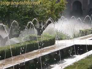


If you click on any of the above images of Granada they will enlarge and sometimes there is more info.
Post by: Ashley on November 26, 2010, 07:55:24 AM
Is it best to go by bus, by taxi or even walking.
Post by: Steven Wellington on November 26, 2010, 08:14:10 AM
https://granadainfo.com/alhambra/minibus.htm (https://granadainfo.com/alhambra/minibus.htm)
The Alhambra is on a hill 100 metres above Granada.
There are several ways of getting to the Alhambra ticket office.
On foot:
Walk up the Cuesta Gomerez (pedestrian only – 1,100m from Plaza Nueva)
Walk up the Cuesta de los Chinos or Cuesta del Rey Chico (pedestrian only – 720m from Plaza de los Tristes)
By bus:
Catch the C3 or C4 minibus
By car:
Via Ronda Sur – the Granada ring road to the Alhambra carpark (map).
See maps of the 2 main minibuses here:
https://granadainfo.com/alhambra/eng_minibus.htm (https://granadainfo.com/alhambra/eng_minibus.htm)
See more information about how to get to the Alhambra here
https://granadainfo.com/alhambra/getting.htm (https://granadainfo.com/alhambra/getting.htm)
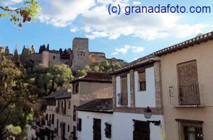
The Albayzin is the old part of town with whitewashed houses.
See more pictures here
https://granadafoto.net/index.php/Barrios---Areas-of-Granada/Albayzin (https://granadafoto.net/index.php/Barrios---Areas-of-Granada/Albayzin)
The Realejo is the other old part of town
See more pictures here
https://granadafoto.net/index.php/Barrios---Areas-of-Granada/Realejo (https://granadafoto.net/index.php/Barrios---Areas-of-Granada/Realejo)
A useful map of Plaza Nueva is here
https://granadamap.com/27.htm (https://granadamap.com/27.htm)